Source: Laboratory of Alan Lester - University of Colorado Boulder
The physical properties of minerals include various measurable and discernible attributes, including color, streak, magnetic properties, hardness, crystal growth form, and crystal cleavage. These properties are mineral-specific, and they are fundamentally related to a particular mineral’s chemical make-up and atomic structure.
This video examines several physical properties that are useful in field and hand sample mineral identification— color, luster, streak, hardness, magnetism, and reaction with acid. Unlike crystal form and crystal cleavage, these properties are somewhat more closely linked to mineral chemical composition than to atomic structure, but both do play a role.
It is important to recognize that rocks are aggregates of mineral grains. Most rocks are polymineralic (multiple kinds of mineral grains) but some are effectively monomineralic (composed of a single mineral). Unlike crystal form and cleavage, which are terms reserved for mineral specimens, geologists might on occasion refer to a rock as having a general sort of color, hardness, magnetism, or reaction with acid. In other words, the physical properties looked at here are potentially appropriate for use with rocks as well as with specific minerals.
Earth Science
Source: Laboratory of Alan Lester - University of Colorado Boulder
The physical properties of minerals comprise various measurable and discernible attributes, including color, streak, magnetic properties, hardness, crystal growth form, and crystal cleavage. Each of these properties are mineral-specific, and they are fundamentally related to a particular mineral’s chemical make-up and atomic structure.
This experiment examines two properties that stem primarily from symmetric repetition of fundamental, structural atomic groupings, called unit cells, within a crystal lattice, a crystal growth form, and crystal cleavage.
Crystal growth form is the macroscopic expression of atomic-level symmetry, generated by the natural growth process of adding unit cells (the molecular building blocks of minerals) to a growing crystal lattice. Zones of rapid unit-cell-addition become the edges between the planar surfaces, i.e. faces, of the crystal.
It is important to recognize that rocks are aggregates of mineral grains. Most rocks are polymineralic (multiple kinds of mineral grains) but some are effectively monomineralic (composed of a single mineral). Because rocks are combinations of minerals, rocks are not referred to as having crystal form. In some cases, geologists refer to rocks as having a general cleavage, but here the term is simply used to refer to repetitive breaking surfaces and is not a reflection of atomic crystal structure. So, in general, the terms crystal form and crystal cleavage are used in reference to mineral samples and not rock samples.
Earth Science
Source: Laboratory of Alan Lester - University of Colorado Boulder
Igneous rocks are products of the cooling and crystallization of high temperature liquid rock, called magma. Magmatic temperatures typically range from approximately 800 °C to 1,200 °C. Molten rock is, perhaps luckily for humans, an anomaly on planet Earth. If a random and imaginary drill hole were made in the Earth, it would most likely not reach a region of truly and totally molten material until the outer core, at nearly 2,900 km beneath the surface (Earth's radius is 6,370 km). Even there, this molten material would predominantly consist of liquid iron, not true silicate rock, and be incapable of ever reaching Earth's surface.
Volcanic eruptions and igneous rocks do occur though, and they are evidence that there are indeed isolated regions of melting and magma generation within the Earth.
Earth Science
Source: Laboratory of Alan Lester - University of Colorado Boulder
Igneous rocks are the products of cooling and crystallization of magma. Volcanic rocks are a particular variety of igneous rock, forming as a consequence of magma breaching the surface, then cooling and crystallizing in the subaerial environment.
Magma is liquid rock that typically ranges in temperature from approximately 800 °C to 1,200 °C (Figure 1). Magma itself is produced within the Earth via three primary melting mechanisms, namely the addition of heat, addition of volatiles, and decompression. Each mode of melt generation tends to produce specific types of magma and, therefore, distinct eruptive styles and structures.
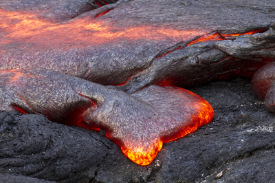
Figure 1. Fresh lava breakout on Kilauea, Hawaii. Lava is the term for magma that is on Earth’s surface.
Earth Science
Source: Laboratory of Alan Lester - University of Colorado Boulder
Most rock units exhibit some form of planar surfaces or linear features. Examples include bedding-, fault-, fracture-, and joint-surfaces, and various forms of foliation and mineral alignment. The spatial orientation of these features form the critical raw data used to constrain models addressing the origin and subsequent deformation of rock units.
Although now over 100 years since its invention and introduction, the Brunton compass (Figure 1) remains a central tool in the modern geologist’s arsenal of field equipment. It is still the primary tool used to generate field data regarding the geometric orientation of planar rock surfaces or linear rock features. These orientation measurements are referred to as strike and dip, and provide the fundamental data for making geologic maps. Furthermore, the Brunton Compass can also function as a traditional compass for location exercises and triangulation. Finally, it can also serve as a pocket transit for measuring angular elevations.

Figure 1. The Brunton compass.
Earth Science
Source: Laboratory of Alan Lester - University of Colorado Boulder
Topographic maps are "plan-view" representations of Earth's three-dimensional surface. They are a standard type of map-view that provides an overhead, or aerial, perspective.
Among the defining features of a topographic map are the contour lines that indicate locations of constant elevation. The elevation interval between the contour lines is dependent on the level of detail provided by the map and the kind of topography present. For example, regions with significant topographic variation might require contour lines separated by 40-100 ft., whereas generally flat-lying regions with little topographic variation might have more broadly separated 10-20 ft. contours.
To an experienced user of such maps, the patterns made by the topographic lines are representative of various landform patterns, such as ridges, valleys, hills, and plateaus.
Earth Science
Source: Laboratory of Alan Lester - University of Colorado Boulder
Geologic maps were first made and utilized in Europe, in the mid-to-late 18th century. Ever since, they have been an important part of geological investigations all around the world that strive to understand rock distributions on the surface of the earth, in the subsurface, and their modification through time. A modern geologic map is a data-rich representation of rocks and rock-structures in a two-dimensional plan view. The base for most geologic maps is a topographic map, onto which color variations have been placed to represent specific rock units. The boundaries between the rock units are called contacts. In addition to the contact lines, geologic maps contain symbols that represent key features, such as the dip and strike of the rock units, anticlines and synclines, and the traces of fault surfaces.
Although the two-dimensional map-view is useful, one of a geologist's key tasks is to infer the type and orientation of rocks in the subsurface. This is done using geologic rules, inferences, and projections downward from the surface. The result is a geologic cross section, a view that essentially provides a cutaway image, much like one would see on a canyon wall or in a roadcut.
This hypothetical slice into the earth, providing a third dimension (depth), is the key to a host of geological applications. Cross sections are used to assess temporal models of rock formation through time. In other words, the goal is to recreate a step-by-step sequence of which rocks and structures came first, last, and in between. They're also used to determine specific modes of deformation - whether rocks have undergone compressional, extensional, or other stresses.
Geologic cross sections help to identify regions of groundwater movement, evaluate potential sites for economic mineral deposits, and locate oil and gas reservoirs.
Earth Science


