All study documentation and data collection methods were approved by and in compliance with the New York University Committee on Activities Involving Human Subjects. Participants gave their informed consent prior to participating in any study-related activities.
1. Setting up gameplay
- Download the necessary files from the following public repository: https://github.com/embodiedbrainlab/BassoSpatialNavigationTask
- Download Unity Hub from unity.com/download and install Unity version 5.3.1f1.
- Open the file downloaded from the repository in step 1.1 as a Project on Unity.
- Once the project has been created with the downloaded files, select the File tab on top of the window and select Build and Run.
- The Build Settings window will first appear. Select SpatialNavigation > Scenes > Big City B Lures and Scenes/LeFin. Select the PC, Mac, & Linux Standalone and then click the Build and Run button.
NOTE: A window will appear asking the researcher to save a .exe (Application) file. Once the researcher has built the application, they can double-click the application to run future iterations of the protocol. If the researcher decides to run this file, its respective results will be saved in the same directory in which the application is located. - A window titled SpatialNavWeb Configuration will appear. Adjust the screen resolution and graphics quality under the Graphics tab. Change the controls of the game under the Input tab.
- Click Play! to begin the spatial navigation task.
2. Recording brain activity with electroencephalography (EEG) during the spatial navigation task
NOTE: EEG measures the activity of neurons in the cortex of the human brain in microvolts on a millisecond timescale through electrodes placed on the scalp. EEG is a noninvasive form of brain imaging that allows a participant's brain to be scanned while they conduct other activities, such as navigating virtual environments.
- Using a measuring tape, measure the participant's head from inion to nasion to ensure the proper fitting of the EEG cap.
- Place electrodes into the EEG cap (if necessary) and outfit the participant with the EEG cap, ensuring proper fitting and placement (Figure 1A).
- Start the EEG software. Fill each electrode with electrode gel to ensure that impedance measurements are below 25 kΩ.
- Once the EEG signal looks clean and without significant artifacts, begin recording.
- Have a member of the research team watch the participant as the participant performs the below steps.
- Send a trigger pulse to the EEG recording system at each of the following events (Figure 1B)
Start of the encoding phase
End of the encoding phase
Start of the remembering phase
End of the remembering phase
Start of the episodic memory phase
End of the episodic memory phase
Any other events that the researcher finds of interest
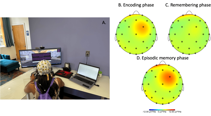
Figure 1: Electroencephalography recording during spatial navigation gameplay. (A) Image of a person equipped with a mobile electroencephalography (EEG) device while performing the spatial navigation task. Power spectral density plot of theta activity (4-8 Hz) during the (B) encoding phase, (C) remembering phase, and (D) episodic memory phase. All data was preprocessed and power normalized by frequency (uV2/Hz). Please click here to view a larger version of this figure.
NOTE: Researchers using Arduino technologies may also be able to send synchronized triggers between the EEG recording and the game-engine environment so that an exact pairing between the neurophysiological and behavioral data can occur on a millisecond timescale. With these markers, researchers will be able to refer back to the participant's brain activity before, during, and after critical interactions with the virtual environment. Researchers may also consider conducting a period of baseline brain activity before and/or after engagement with the virtual environment so that later comparisons can be made.
3. Instructions for the spatial navigation task (Figure 2)
- Instructions: Ensure that the participant is seated comfortably, ideally with their feet on the floor. Have the participant read the instructions on the screen, which will ask them to visit specific landmarks within a cityscape while trying to remember their surroundings and the paths they took (Figure 2A).
- Ensure that the participant is oriented to the mouse and the keyboard. Instruct the participant to use the mouse and left-click to begin the task (Figure 2A).
- Ensure the participant understands that they will need to navigate the environment with the W, A, S, and D keys on their keyboard.. The W key will move them forward, whereas the S key will move them backward. Alternatively, the up and down arrows will also move them forward and backward. The A key will move them to the left, and the D key will move them to the right.
- Ensure that the participant knows they can use the computer mouse to move the subject's point of view as if the participant were moving the head. Participants can look up, down, left, and right; no mouse clicks are necessary to move their point of view.
NOTE: Directions on navigating the virtual environment will appear in the top right corner of the participants' screen (Figure 2A-F).
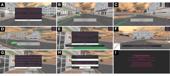
Figure 2: Images of spatial navigation task. Screenshots of the spatial navigation and episodic memory task developed in a cross-platform game engine. Example screenshots are presented from left to right, starting at the top left corner: (A) overall instructions; (B) travel during encoding phase; (C) locating storefront during the encoding phase; (D) travel during encoding phase; (E) instructions for remembering phase; (F) delivery portion of remembering phase; (G) instructions for episodic memory phase; (H) episodic memory phase; (I) end of game. Please click here to view a larger version of this figure.
4. Encoding phase of the spatial navigation task
- Have the participant visit the first landmarks (Figure 3) by having them actively follow a green path with green arrows (Figure 2B).
- Once the participant arrives at the first landmark, have the participant walk through the green diamond at that location (Figure 2C).
- Once the participant collects the green diamond, have the participant visit the next landmark by following the green path. Once the participant arrives at the second landmark, have the participant walk through the green diamond at that location.
- Have the participant continue performing this task until the participant visits all five landmarks and collects all five diamonds (Figure 2D).
NOTE: Throughout the encoding phase of this task, participants will be asked to memorize the location of the five landmarks throughout the city (Figure 3). A bird's-eye view of the task is presented in Figure 4.
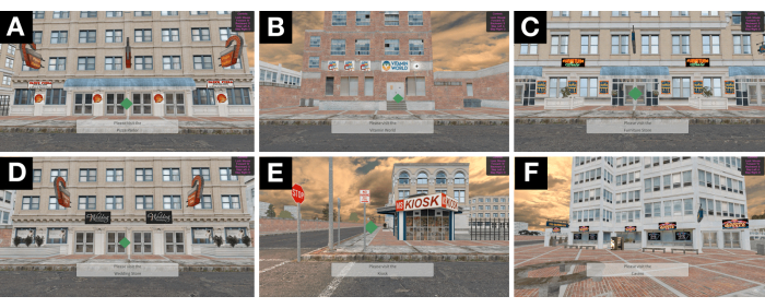
Figure 3: Images of storefronts. Participants visited five of the eighteen locations developed in the environment, each with a unique and detailed storefront. Examples of these locations included (A) a pizza parlor, (B) a vitamin shop, (C) a furniture store, (D) a wedding store, (E) a kiosk, and (F) a casino. Please click here to view a larger version of this figure.
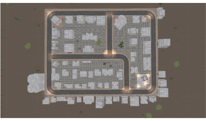
Figure 4: Map of spatial navigation task. Bird's eye view of the virtual environment through which participants navigated. Please click here to view a larger version of this figure.
5. Remembering phase of the spatial navigation task
- Next, have the participant revisit each landmark (i.e., remembering phase; Figure 2E).
NOTE: Participants will begin the remembering phase from the last location they visited during the encoding phase. - Have the participant use the mouse and left-click on top of Begin (Figure 2E).
- Have the participant visit the first landmark that the participant visited during the encoding phase.
- Have the participant "deliver" a unique item to this first landmark.
NOTE: No green path/arrows will be offered during this portion of the task (Figure 2F). - Once the participant delivers the item, have the participant navigate to the second landmark and deliver the next unique item. Have the participant continue performing this task until the participant visits all five landmarks and delivers all five items.
NOTE: This portion of the task will assess the participant's spatial learning and memory ability. To do this, the program will automatically calculate the time to find each landmark, the average seek time, and the total time of the task.
6. Episodic memory phase of the spatial navigation task
NOTE: Episodic memory testing will take place after the remembering phase is complete.
- To begin, have the participant use the mouse to left-click on top of Begin (Figure 2G).
- Have the participant recall the landmarks the participant visited and the items the participant delivered in the exact order as instructed earlier in the remembering phase (Figure 2G). Have the participant type the responses using the computer keyboard (Figure 2H).
7. Completing the task
- Have the participant read the final prompt to confirm the completion of the task and the submission of the data (Figure 2I).
8. Data collection and analysis
- Behavioral data
- Locate the Results.csv file in the application's directory (see Supplementary File 1 for example).
NOTE: If the researcher decides to click Build and Run under the File tab on the Unity Application, the Results file will be saved in the downloaded BassoSpatialNavigationTask-main folder. If the researcher instead ran the environment by double-clicking the built Application (step 1.5), the Results file will appear in the same directory as the application. The Results file is overwritten after each completion of the virtual environment. Thus, it is recommended to extract these results after each completion of the task and compile them in a separate file for multiple participants and trials. - Ensure that the data is clean and looks reasonable.
- Utilize Supplementary File 2 to calculate the appropriate scores, including start time, end time, average seek duration, place score, item score, order score, association score, and episodic memory score.
NOTE: Specifically, the place score is calculated by tallying the number of landmarks correctly recalled. Order score is calculated by determining the number of landmarks recalled in the correct sequence. Item score is calculated by tallying the number of items correctly recalled. The association score is calculated by tallying the correct pairing of place to item. Finally, the overall episodic memory score is calculated by summing the place, order, item, and association scores. Note that the raw output for the X/Z coordinates is not in the correct temporal sequence. To remedy this, sort the data in the Time column from the smallest to largest values. - Enter the data into a database of choice.
- Analyze the data using independent samples t-test, analysis of variance, or other appropriate statistical tests.
- Locate the Results.csv file in the application's directory (see Supplementary File 1 for example).
- EEG data
- Use a preprocessing pipeline to clean the EEG data25.
- Using an appropriate software package, conduct time-frequency analysis on EEG data over prolonged periods of time in which the participant navigated the virtual environment, such as during the encoding and remembering phases of the task.
- Conduct event-related potential analysis if interested in specific time periods that the participant interacted with the virtual environment.
- Conduct statistical analysis relevant to the EEG data and consider correlating the behavioral data with the EEG data.
Description of gameplay from a coding perspective: For the "encoding" phase, a series of eighteen waypoints were placed around the 3-dimensional space, with each having an associated "Delivery Item" (i.e., item to deliver to the location). References to these waypoints were stored in the player controller and ordered statically prior to beginning the task; that is, if the pizza shop was placed in position one, it would always be in position one at first. In order to provide some degree of randomness to the waypoints that participants encountered, the waypoint list was shuffled via the Fisher-Yates shuffle algorithm. The Fisher-Yates shuffle, as implemented for this study, generates a pseudorandom permutation of the original sequence in place. Any possible permutation can be generated with equal likeliness. The algorithm begins by selecting an element from the end of the list (n). A pseudorandom number is generated in the range of [0, n] and assigned to the value k. The nth value is then swapped with the kth value. Next, the value of n is decremented by one, and the process repeats until there is only a single index not yet considered.
After the list of waypoints was shuffled, the first five elements were selected. Optimal paths were generated via the game engine's navigation mesh system and built-in optimal path calculations. This series of paths began at the starting location of the participant and created a linked chain between each of the waypoints, terminating at the final waypoint. When the participants gained control, they were directed to follow these paths, designated by a green line and a moving arrow that provided intended direction information. Though this green line and moving arrow were provided, participants were able to actively navigate throughout the virtual environment. When the participant entered the bounds of the waypoint, the displayed path was swapped with the next path in the list.
Upon visiting the intended number of waypoint elements, the participant entered the "remembering" phase (termed RevisitIntermission in the code), where they were directed to revisit the landmarks in the order that they were previously shown. As the participant attempted to revisit the locations presented during the guided tour, they were presented with an image specified by the waypoints' associated "Delivery Item". They were not presented with a suggested path. Their movements were tracked with an object motion tracker component sourced from the asset store.
When the participants finished traveling to each presented waypoint, they were given instructions directing them to the next screen to recall the locations they had visited and the items delivered to each one. During the recall phase, the participants were presented with a prompt with two text entries. The first dictated the waypoint the participant was asked to travel to. The second dictated the "Delivery Item" associated with this waypoint. Response and response time were recorded for each prompt.
At the end of the task, the data were collected and stored in JSON representation. The first section recorded the revisit phase, where participants were asked to find locations without the aid of a guiding line. Recorded values included the waypoint name, the "Delivery Item" name, and the time it took to arrive at the waypoint. The second section recorded the responses presented during the recall phase. This section included participant responses for location, "Delivery Item", and the time it took to respond to the aforementioned prompts. All code can be found and downloaded at https://github.com/embodiedbrainlab/BassoSpatialNavigationTask.
Power analysis and statistics: A correlation point biserial model power analysis was conducted with G*Power 3.1 using a two-tailed test, an effect size of 0.3, alpha level of 0.05, and a power of 0.8 to determine a sample size of n = 8226. Descriptive statistics were used to assess participants' age, number of cycling classes, and general measures, including both spatial navigation and episodic memory abilities. An independent samples t-test was utilized to test significant differences between the total number of workouts between experimental and control groups. Considering that not all data were normally distributed, as assessed by Shapiro-Wilk's test (p<0.05), we utilized the non-parametric Spearman's rho correlation coefficient to assess relationships between spatial navigation and episodic memory abilities as well as age and spatial navigation abilities. An alpha value of 0.05 was utilized to determine statistical significance. Bonferroni corrections were used in a family of statistical tests where appropriate. IBM SPSS Statistics Version 26 was utilized for all statistical analyses. Pearson's product-moment correlation was utilized to assess the relationship between the total number of cycling workouts and spatial navigation abilities, as this was the procedure conducted by Basso et al. (2022)27.
Participants: N = 130 participants were recruited from Austin, TX, through various techniques, including online and flyer advertisements. Inclusion criteria included having English as their primary language and being between the ages of 25-55 years of age (average 30.16 ± 0.49). Additionally, all participants needed to report being physically healthy and having a moderate and regular exercise regimen (defined as exercising one or two times per week for 20 min or more for the past 3 months). Exclusion criteria included being a current smoker or preexisting physical health conditions that made exercise difficult or unsafe. Exclusion criteria also included having a current diagnosis of and/or taking medication for psychiatric or neurological conditions, including anxiety, depression, bipolar disorder, schizophrenia, or epilepsy.
For pre-intervention data, n = 11 participants were missing data due to technical issues, and n = 1 participant was excluded due to non-task adherence, leaving a total of n = 117 participants for analysis. Of the n = 80 participants that completed the three-month exercise regimen, n = 11 participants did not complete the final spatial navigation task, leaving a total of n = 69 participants for analysis of post-intervention and repeated measures data. This smaller sample size was utilized to examine the relationship between the number of cycling sessions and spatial navigation abilities. The control group engaged in 20.73 (± 0.72) workouts over the course of the intervention, whereas the experimental group engaged in 47.87 (± 2.24) workouts, which represented a statistically significant difference (t[45.76] = −11.554, p < 0.001).
General measures and their relationships: This new virtual environment task measures both spatial navigation and episodic memory capacity. During the initial pre-intervention testing period, the task took an average of 318.69 (±21.56) s to complete, with the average seek time for each of the five sites being 82.88 (±5.19) s (Figure 5A); these data points represent spatial navigation ability (i.e., spatial learning and memory). Additionally, participants were able to encode place, item, order, and association aspects of the virtual experience, with participants remembering 14.84 (±0.37) out of 20 novel experiences in their environment (Figure 5B); these data points represent episodic memory ability. Importantly, the total time (Figure 6A; r = -0.314, p < 0.001) and average seek time (Figure 6B; r = -0.286, p < 0.001) were significantly correlated with the episodic memory score, indicating that spatial navigation ability is associated with episodic memory in this task.
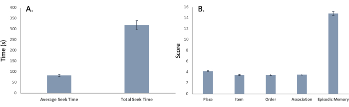
Figure 5: Time of task. Mean (± SEM) for both (A) spatial navigational ability represented in both average seek time and total seek time (provided in seconds) and (B) episodic memory ability represented in the encoding and remembering of place, item, order, association and overall episodic memory score. Please click here to view a larger version of this figure.
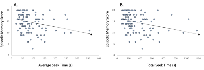
Figure 6: Relationship of spatial navigation ability to episodic memory. Improved spatial navigation ability as represented by shorter (A) average seek time and (B) total seek time is associated with enhanced episodic memory as represented by the episodic memory score. *p < 0.001. Please click here to view a larger version of this figure.
X and z coordinates represented in virtual space: Using an object motion tracker asset, x and z coordinates were tracked in this 3-dimensional virtual space (Supplementary File 1). As moving up and down in the game (i.e., jumping) is not enabled in this spatial navigation task, y coordinates did not provide useful information. However, the x and z coordinates enabled us to assess how the participant moved throughout the game. Based on this data, computer code was designed to visually display a heat map of where the participant traveled throughout the map. Figure 7 displays a heat map from one representative participant, which highlights the route the participant took during the remembering phase. The spots that are highlighted in yellow/red correspond to the delivery (i.e., reward) locations on the map.
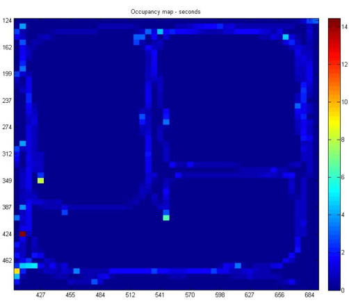
Figure 7: Occupancy heat map. Occupancy heat map demonstrating the route of the participant. Yellow/red sections of the graph represent those locations where the participant frequented and correspond to places in the spatial navigation task where participants had to deliver items (i.e., reward locations). Please click here to view a larger version of this figure.
Relationship between age and spatial navigation abilities: Initial investigations indicated that spatial navigation ability as assessed by total seek time was significantly associated with age (Figure 8; r = 0.157, p = 0.045). As age increases, spatial navigation ability decreases, as evidenced by an increased total seek time. However, when the Bonferroni correction was applied, with statistical significance being assessed at p = 0.025 for two correlations (i.e., total seek time and average seek duration), the correlation was no longer significant.
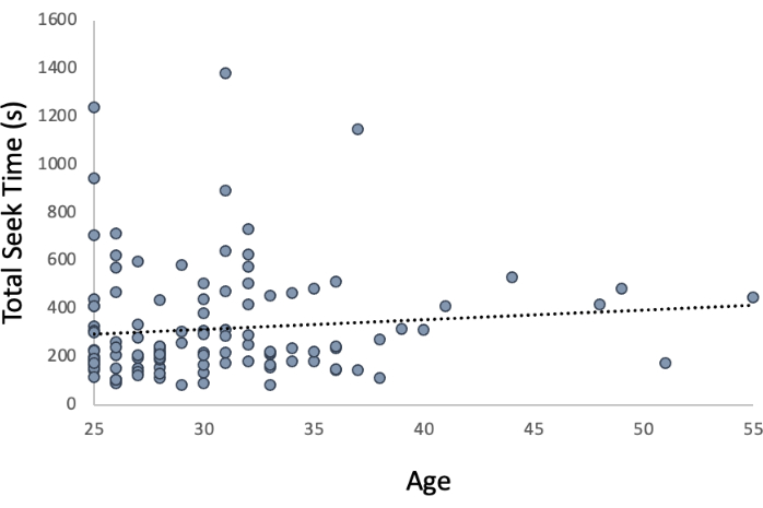
Figure 8: Relationship of spatial navigation ability to age. When evaluated using a Bonferonni correction (p < 0.025), age was not significantly associated with spatial navigation ability as represented by total seek time. Please click here to view a larger version of this figure.
Relationship between aerobic exercise training and spatial navigation abilities: Aerobic exercise training took place at an indoor cycling studio28. All classes were 45 min in duration and included cycling at moderate to vigorous intensities throughout the duration of the class. Participants underwent random assignment to either maintain their existing exercise regimen or increase their exercise regimen. Participants who maintained their exercise regimen engaged in 1 to 2 classes per week, whereas participants who increased their exercise regimen engaged in 4 to 7 classes per week. Participants engaged in their assigned exercise regimen for a period of 3 months. Spatial navigation and episodic memory ability were tested before and after exercise training. Additional details of the intervention can be found in Basso et al. (2022)27. The total number of cycling classes over the course of three months was significantly associated with average seek duration (Figure 9A; r = -0.321, p = 0.007) and total seek time (Figure 9B; r = -0.242, p = 0.045). However, when the Bonferroni correction was applied, with statistical significance being assessed at p = 0.025 for two correlations (i.e., total seek time and average seek duration), the correlation for total seek time was no longer significant. Additional findings from the intervention can be found in Basso et al. (2022)27.
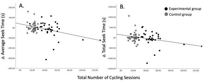
Figure 9: Relationship of spatial navigation ability to exercise. An increased number of cycling sessions is associated with improved spatial navigation ability as represented by (A) average seek time and (B) total seek time. *p < 0.05. This figure has been modified with permission from Basso et al.27. Please click here to view a larger version of this figure.
Supplementary File 1: Raw data 1. Raw data, including information regarding the remembering (revisit) and episodic memory (recall) phase of the spatial navigation task. Data regarding the participant's x and z coordinates from traveling around the 3-dimensional virtual space during the encoding and remembering phases of the experiment is also presented. Please click here to download this File.
Supplementary File 2: Raw data 2. Raw data with calculations (presented in red) to determine start time, end time, average seek duration, place score, item score, order score, association score, and episodic memory score. Please click here to download this File.